

Luke – Leaders Guide and Map Collection
Original price was: $39.00.$20.00Current price is: $20.00. SALE
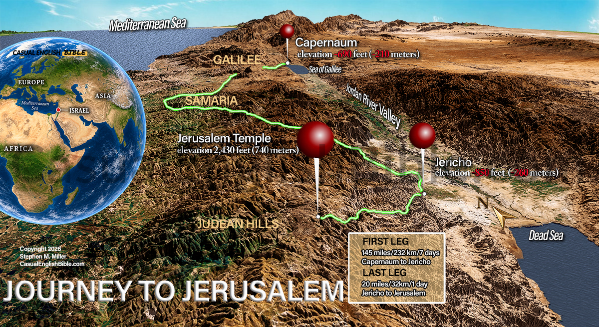
Jesus’ Journey to Jerusalem Map – Luke 18
$10.00
Jesus knew where this road would end. His disciples didn’t.
Jesus was heading toward Jerusalem, where he told his disciples he would be mocked, beaten, and killed. They couldn’t understand what he was telling them. Ahead lay Jericho, a grueling climb through the Judean hills, and the city where his final days would unfold. (Luke 18:31–34)
Description
The long road to Jerusalem—and the crucifixion
For travelers coming south from Galilee, the Jordan River Valley offered a route toward Jerusalem that avoided the mountainous interior of Samaria. From Capernaum, the journey to Jericho covered roughly 90 miles (145 kilometers), about five days on foot.
As Jesus approached Jericho, a blind beggar heard the commotion of the passing crowd and shouted for help. People tried to silence him, but he shouted louder. Jesus stopped, spoke with him, and restored his sight. The man followed Jesus, praising God. (Luke 18:35–43)
In Jericho, Jesus encountered Zacchaeus, a wealthy tax collector so eager to see him that he climbed a tree. To the surprise of the crowd, Jesus invited himself to Zacchaeus’s home. The encounter transformed the tax collector’s life. (Luke 19:1–10)
From Jericho, the road climbed approximately 20 miles (32 kilometers) into the Judean hills—a strenuous day’s walk that rose more than 3,000 feet (900 meters) toward Jerusalem. The contrast was dramatic: Jericho stood about 850 feet below sea level, while Jerusalem’s Temple Mount rose to approximately 2,430 feet above it.
As Jesus neared Jerusalem, crowds welcomed him as king. But he wept over the city, knowing the suffering that lay ahead. Within days, he would be arrested, condemned, and crucified. (Luke 19:28–44; 22–23)
This 3D-style terrain map brings the final approach to Jerusalem into perspective, revealing the distances, elevations, and rugged landscape behind one of the most consequential journeys in the Bible.
What you get
- A downloadable, full-color 3D-style Bible map illustrating the journey from Galilee through Jericho to Jerusalem.
- Option to license for publication
- A highlighted route showing the approximately 90-mile journey to Jericho and the final 20-mile ascent to Jerusalem.
- Elevation comparisons for Capernaum, Jericho, and Jerusalem’s Temple Mount.
- A locator globe showing the region’s position in the Mediterranean world.
- A visual reference for teaching and studying Luke 18–19 and the events leading to Jesus’ crucifixion.

Enhanced Complete Bible Map Library License
What if you could follow the entire Bible on a map—chapter by chapter?
This is every map we’ve created for the Casual English Bible®, all in one place. If geography shows up in a chapter, there’s a map for it. And as new maps are added, they’re included—no extra cost.
You’re not just reading the story anymore. You’re seeing where it happened.
$75.00 / year


Reviews
There are no reviews yet.