
Luke – Leaders Guide and Map Collection
Original price was: $39.00.$20.00Current price is: $20.00. SALE
Jesus’ Journey to Jerusalem: Biblical Map of His Final Trip Through Judea and Galilee
$10.00
Follow Jesus on His Journey Toward Jerusalem
What route might Jesus have taken on his final journey to Jerusalem, and what did he pass along the way? From the villages of Galilee to Jericho and the hills of Judea, the landscape helps bring the final chapters of Jesus’ ministry to life. Explore the regions ruled by Herod Antipas and Herod Philip, the Roman-controlled territories, and a possible route Jesus traveled as he moved toward the city where his final days would unfold.
Description
Narrative Description
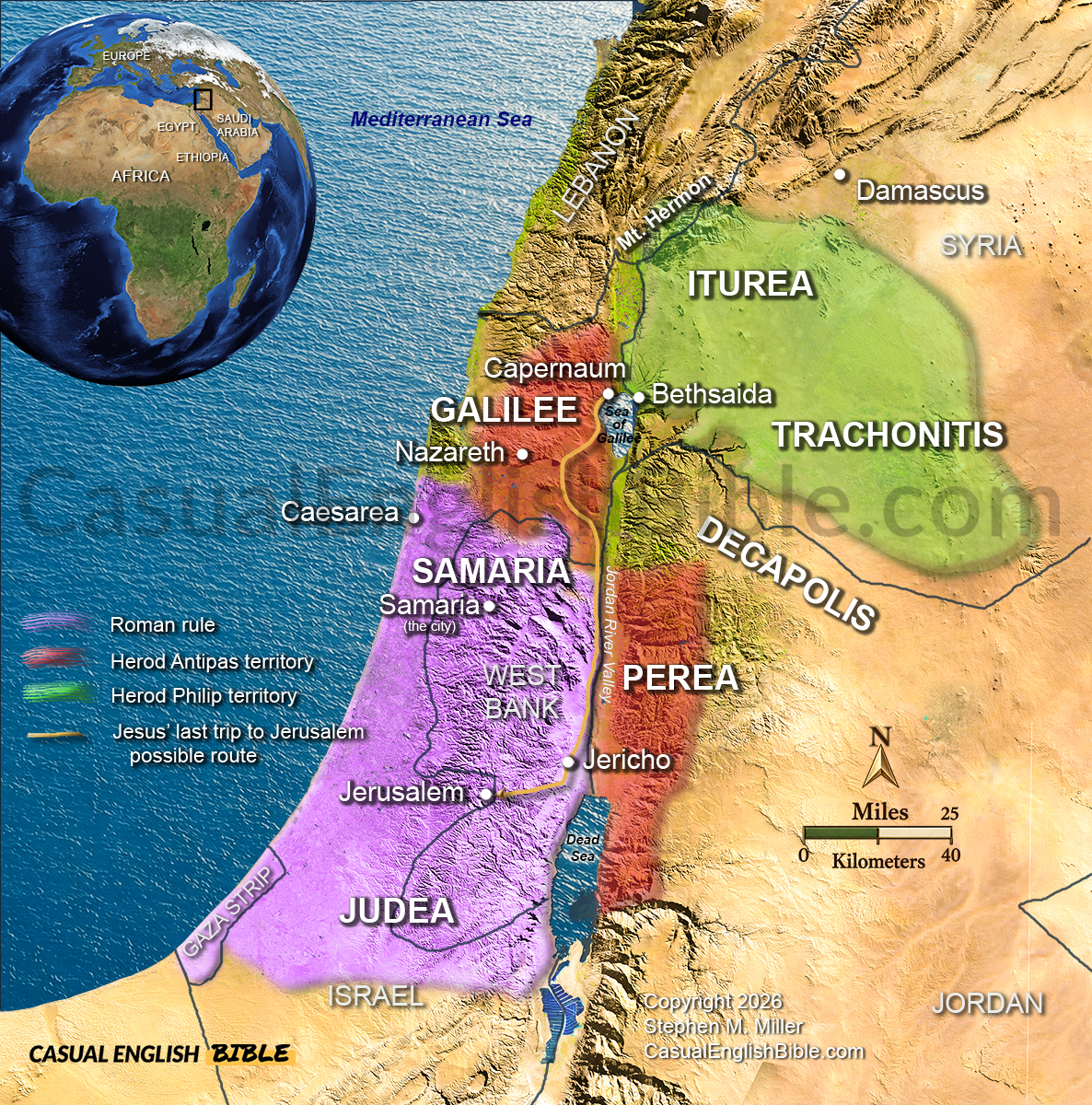
Jerusalem was the destination of Jesus’ final journey, a journey that the Gospels describe as a turning point in his ministry. Jesus spent much of his public life teaching and healing in Galilee, where towns such as Capernaum, Bethsaida, and Nazareth were important places in his story. As he traveled south toward Jerusalem, he moved through a region shaped by Roman rule and territories governed by members of the Herodian family.
This map highlights Galilee, Samaria, Judea, and the surrounding lands east of the Jordan River. During Jesus’ lifetime, Herod Antipas ruled Galilee and Perea, while Herod Philip governed territories farther northeast. Judea and Samaria were under Roman administration during much of Jesus’ ministry. These political boundaries help explain the varied settings in which Jesus taught, encountered different communities, and continued his journey toward Jerusalem.
The route marked on the map represents a possible path for Jesus’ final journey, passing through the Jordan River Valley near Jericho before reaching Jerusalem. The Gospel accounts describe Jesus traveling toward Jerusalem, but they do not provide a single, detailed itinerary that establishes every stop shown on this route. The map therefore offers geographical context rather than a definitive reconstruction of his exact movements.
Understanding the landscape makes the Gospel story easier to follow. The Sea of Galilee, the Jordan River Valley, the Dead Sea, and the hills surrounding Jerusalem shaped how people traveled between regions. As you explore these places, you can better understand the distance Jesus traveled, the political world he lived in, and the significance of his arrival in Jerusalem before his crucifixion and resurrection.
The Complete Bible Map Library
More than 1,000 Bible maps: Get a feel for the lay of the land
What if you could follow the entire Bible on a map—chapter by chapter?
This is every map we’ve created for the Casual English Bible®, all in one place. If geography shows up in a chapter, there’s a map for it. And as new maps are added, they’re included—no extra cost.
You’re not just reading the story anymore. You’re seeing where it happened.
SALE Original price was: $80.00.$75.00Current price is: $75.00.