Jeremiah Bible Atlas - PDF
Mizpah Murder
$10.00
What you get when you purchase this map
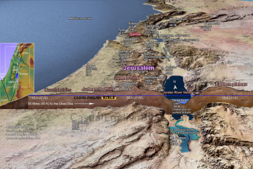
- High-resolution 3D map of Mizpah, Jerusalem, and Rabbah
- Clearly marked 50-mile (80 km) escape route across the Jordan River
- Biblical context connecting Jeremiah 40–41 to Gedaliah’s assassination
- Geographic perspective showing terrain, valleys, and regional borders
- Accurate placement of key locations including Mizpah, Jericho, and Rabbah
- Instant digital download for teaching, study, or presentation
Description
Murder in Mizpah: Escape Route Map (Jeremiah 40–41)
This Bible map of Mizpah and Rabbah traces a violent and chaotic moment in Judah’s final days after Babylon conquered Jerusalem.
After the fall of the city, Babylon appointed a governor named Gedaliah to rule the remaining people. His base was Mizpah, just north of Jerusalem. But the fragile peace didn’t last. A member of Judah’s royal family assassinated him, throwing the region into panic (Jeremiah 40–41).
This map follows the escape route east from Mizpah across the Jordan River toward Rabbah in Ammon—about 50 miles (80 km). It shows how quickly the situation unraveled, as survivors fled for safety and power shifted again in the aftermath of the conquest.
By placing the story on the land, this map highlights the distance, direction, and urgency behind the escape—turning a brief biblical account into a visible, traceable event.
What you get when you purchase this map
- High-resolution 3D map of Mizpah, Jerusalem, and Rabbah
- Clearly marked 50-mile (80 km) escape route across the Jordan River
- Biblical context connecting Jeremiah 40–41 to Gedaliah’s assassination
- Geographic perspective showing terrain, valleys, and regional borders
- Accurate placement of key locations including Mizpah, Jericho, and Rabbah
- Instant digital download for teaching, study, or presentation