Numbers Bible Atlas
$39.00
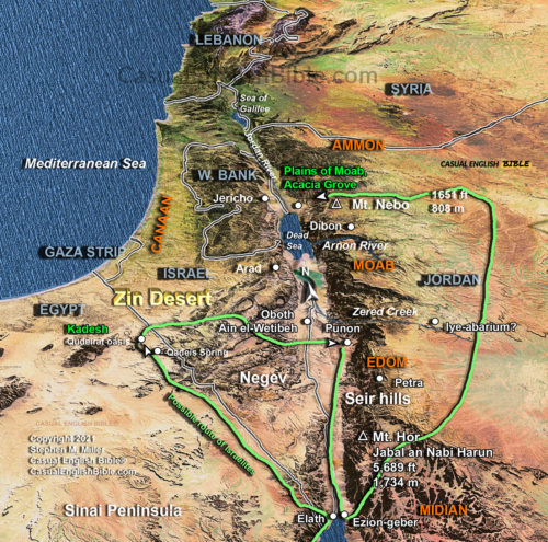
Canaan, the Promised Land
$10.00
What you get
- Custom-made for The Casual English Bible®
- High-resolution JPG image
- Map of Canaan showing regions, terrain, and key locations
- Available for immediate download
- Licensing available for publication
Description
The land shaped the people
This map shows the land of Canaan—the Promised Land—and how its geography shaped where people lived, how they farmed, and how they fought.
The Jordan River runs down the center of the land, providing a vital source of water. Around it, the landscape shifts quickly—from fertile valleys to rugged hills and dry regions. These differences influenced where Israelites settled and how they defended themselves.
Life in the hill country
Many Israelites settled in the central hill country. The higher ground offered natural defense and a safer place to live. Cities built on hills were harder to attack, and the terrain gave local fighters an advantage over larger armies.
Other groups lived in different regions, depending on what the land offered—fertile soil, access to water, or strategic position.
Philistines on the coast
Along the coastal plain lived the Philistines, one of Israel’s most powerful enemies. Their land was flat, fertile, and well-connected to trade routes, giving them both economic strength and military advantage.
Many of the Bible’s battles—like David and Goliath—grew out of this tension between the hill country and the coast.
A land of constant conflict
Israel also faced pressure from other neighboring peoples, including the Canaanites, Amorites, and Moabites. Much of the fighting centered on key resources—water, farmland, and strategic routes through the land.
This map helps you see those pressures. It turns familiar names into real places and shows how geography shaped the story of Israel.
What you get
- Custom-made for The Casual English Bible®
- High-resolution JPG image
- Map of Canaan showing regions, terrain, and key locations
- Available for immediate download
- Licensing available for publication