John the Baptist on the map
$10.00
What You Get
- A detailed map of the region connected to the Matthew 14 story
- Designed especially for The Casual English Bible®
- High-resolution PDF (2000 pixels) for sharp print and digital use
- Instant download
- Optional licensing for books, churches, classrooms, and other publications
Description
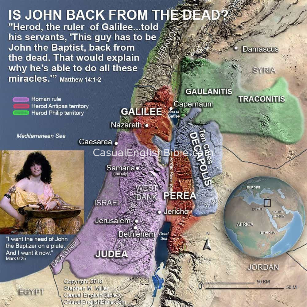
Map of the Region in Matthew 14 — “The Death of John the Baptist”
A Dark Moment in a Real Place
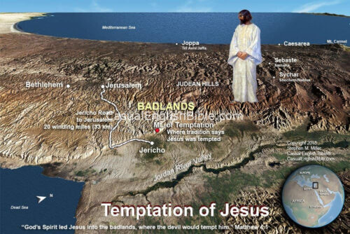
This map shows the region connected to one of the most intense and tragic moments in the life of Jesus — the execution of John the Baptist. In Matthew 14, John is arrested by King Herod and held in a fortress-palace. During a royal banquet, a reckless promise leads to John’s beheading.
This wasn’t just a story that happened “somewhere.” It happened in a real place, controlled by a real ruler, inside a real stronghold on the edge of the Jewish world.
Why the Geography Matters
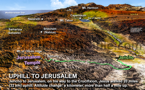
John was being held at a fortified palace east of the Jordan River, far from the crowds that once followed him. This area was ruled by Herod Antipas, who controlled Galilee and the surrounding regions. The map shows how this remote, heavily guarded location stood in sharp contrast to the open lakeshore towns where Jesus was teaching.
When John was killed, word had to travel from this isolated palace back across the region to reach Jesus. The geography helps you feel the weight of that distance — and the danger in the political world they were living in.
How This Connects to Jesus
After hearing about John’s death, Jesus leaves the area by boat, crossing the Sea of Galilee to find a quiet place. This map lets you see how close everything was — the palace, the towns, the water, the roads — and how tightly woven politics, faith, and fear really were.
Seeing the landscape makes the story feel less like a legend and more like history you could almost step into.
What This Map Shows
This map lays out the key locations behind Matthew 14 — Herod’s territory, the palace where John was imprisoned, and the nearby towns and waters that shaped what happened next. It turns a shocking story into something grounded in real geography you can follow with your eyes.
What You Get
- A detailed map of the region connected to the Matthew 14 story
- Designed especially for The Casual English Bible®
- High-resolution PDF (2000 pixels) for sharp print and digital use
- Instant download
- Optional licensing for books, churches, classrooms, and other publications

Matthew - Leaders Guide & Atlas
What You Get
- 40 high-resolution Bible maps covering the full Gospel of Matthew
- 275 Q&A Leader’s Guide questions based on real reader curiosity
- Clear, honest answers—including “we don’t know” where appropriate
- 127 pages of ready-to-use teaching and discussion material
- Geographic context for key events from birth to resurrection
- Instant PDF download with optional licensing for broader use
$49.00