Elijah's chariot of fire
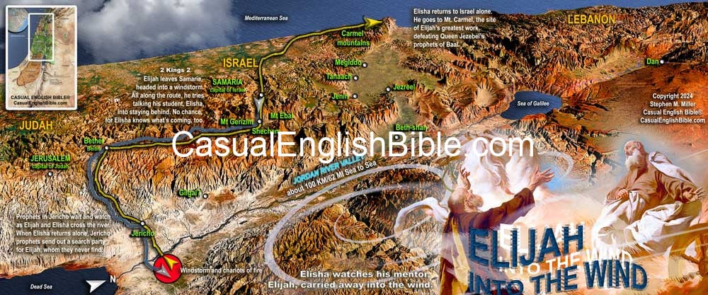
Elijah's walk into the wind
Elijah didn't die, according to Bible writers. He was carried away on the wind while his colleague, Elisha, watched as "horses of fire pulling a chariot of fire charged at the men—driving between them and separating them. Then a powerful wind knocked Elijah off his feet and carried him into the sky" (2 Kings 2:11). Elisha started screaming, “Father! Father! Israel’s chariots and calvary!” (2 Kings 2:12).Experts try to explain what happened
Scholars don’t agree about how to explain what just happened. Was it a theophany—a physical expression of a spiritual or celestial event? Or was it physical and literal—horses that could toast a hotdog? Was it physical and metaphorical—lightning and a tornado or maybe an intense thunderstorm associated with a powerful dust storm? Or was it a vision of heaven’s military carrying Elijah away.Did Elijah die?
What remains of the story is the teaching that Elijah never died. Jews today set a cup of wine out for Elijah at every annual Passover meal known as a seder. Some teach that Elijah will come before the Messiah comes, as one prophet seemed to predict (Malachi 4:5). Jesus later taught that John the Baptist fulfilled that prophecy (Matthew 11:14).Elisha's request
Before the windstorm, while still on the walk, Elisha asked if he could take Elijah's role as the lead prophet: “Please, let me be the one to inherit the position you’re leaving behind" (2 Kings 2:9). And that's what happened. A group of prophets in Jericho said so: “The ministry of Elijah now rests on Elisha’s shoulders” ( 2 Kings 2:15).Elisha's ministry
The Hebrew word for “ministry” is ruah, which has many meanings: breath, wind, spiritual essence of a person, spirit being. In the context of the story, the prophets seemed to recognize that Elijah’s ministry as Israel’s leading prophet had just fallen to Elijah’s apprentice, Elisha.For more Bible features
Jezreel insurrection
Jezreel insurrection
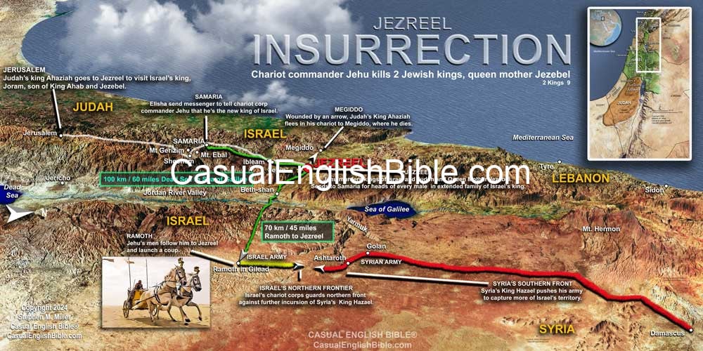
Chariot commander leads insurrection at Jezreel
The is what happened when one of Israel's chariot corps commanders, on a mission to crown himself king, leads an insurrection in the city of Jezreel, the king's getaway palace."At Jezreel, a guard in the city tower saw a group of people coming. He said, 'We’re about to get company.' ...
Joram said, 'Get my ride.' They brought his chariot and he rode out to meet Jehu. Judah’s King Ahaziah came, too, in his own chariot. The kings met Jehu on the property of Naboth, who lived in Greater Jezreel, outside the walls. Joram asked Jehu, 'Is it going to be peace, Jehu?' And Jehu said, 'Peace? How can there be peace when our people worship idols and practice sorcery, which your mother Jezebel brought here?'
ISRAEL’S KING SHOT IN THE HEART
Joram turned his horses around and yelled, 'Traitors, Ahaziah!' Jehu raised his bow and shot an arrow into Joram’s heart. The king collapsed in his chariot.Jehu told an officer named Bidkar, 'ump his body here on Naboth’s land. Remember back when we rode with his father Ahab, and we heard that prophecy from the LORD against him? ‘The LORD says that for the murder of Naboth and his sons, Ahab would pay for it on this plot of land.’ So, roll him out of the chariot and leave him here, since the LORD said it would happen this way.'
JUDAH’S KING SHOT DEAD
Judah’s King Ahaziah saw what Jehu did, and he raced away in the direction of Beth Haggan. Jehu followed and told his men, 'Shoot him, too!' They shot him as his chariot started to make the climb to Gur, near the town of Ibleam. Wounded, he rode to Megiddo and died there. Some of his soldiers carried his body back to Jerusalem in a chariot. His people buried him in the City of David among his ancestors.Ahab’s son Joram was in the eleventh year of his reign in Israel when Ahaziah became king of Judah." 2 Kings 9:14, 7-22, Casual English Bible
For more Bible features
Jezreel Insurrection
Tirzah to Shiloh
Tirzah to Shiloh
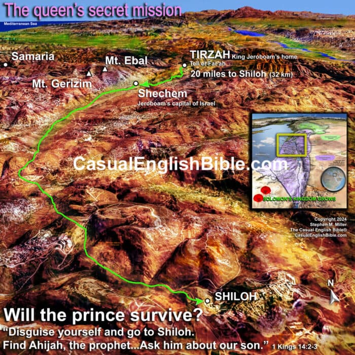
THE QUEEN’S SECRET MISSION
King Jeroboam’s son Abijah, got sick. The king told his wife, “I want you to disguise yourself and go to Shiloh. Find Ahijah, the prophet who predicted I would be king. Take him some gifts: 10 loaves of bread, a few of those little sweet cakes, and a jug of honey. Then ask him about our son. He’ll tell you what’s going to happen.”The queen and the prophet
Jeroboam’s wife went to Ahijah’s house in Shiloh. The prophet was old and blind by this time. But the LORD had told him, “Jeroboam’s wife will be coming to ask you about her son. He is sick. She will pretend she’s another woman. So, here’s what I want you to say.” And God gave him the message. Ahijah heard her footsteps when she stepped inside. He said, “Come on in. Jeroboam’s wife is welcome here. Why are you pretending to be someone else? I have some heavy news for you to carry home.GOD’S MESSAGE FOR THE KING
Here’s what you need to tell Jeroboam. Tell him this message comes from the LORD, the God of Israel: ‘I picked you out of the vast crowd and made you leader of my people, Israel. I tore a huge part of the kingdom away from David’s family. His children weren’t like David, and neither are you. David obeyed the law. He stayed devoted to me with all his heart. He wanted nothing more than to please me. You’ve got more evil in you than all the evil people who ever lived. You invented your own gods, stuck them in a mold, and turned them into statues. You made me angry, and you made me your enemy. I’m going to toss you out like yesterday’s trash. No male under your roof will survive—sons or slaves, it won’t matter which. Your family dynasty will disappear like dried manure thrown into a fire. If your people die in the city, their bodies will feed the dogs. If they die in fields, birds will pick them apart.’GOD’S MESSAGE FOR THE QUEEN
Now go back home to your family. When you step foot into the city, your son will die. Taken from 1 Kings 14:1-12For more Bible features
Stephen M. Miller's website , The Casual English Bible, and Bible YouTube channelSolomon’s 12 administrative districts
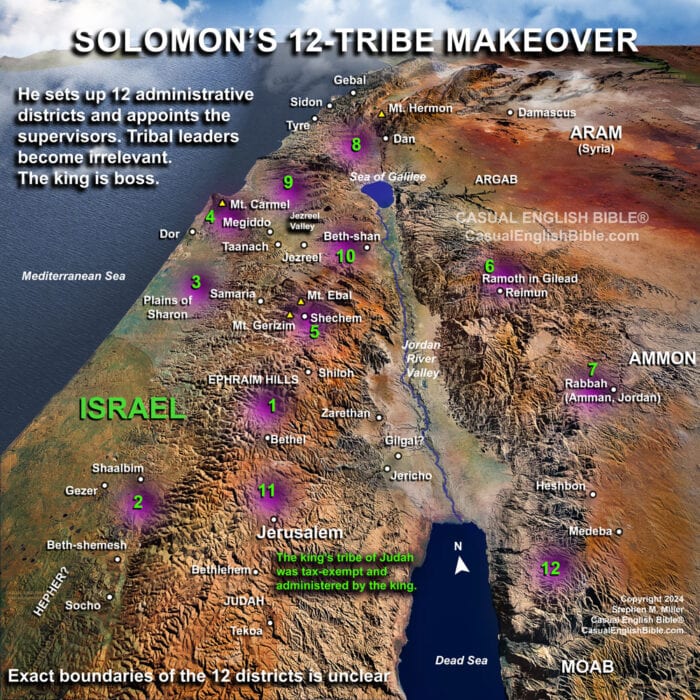
Solomon's 12 administrative districts
Solomon replaces tribal leaders
He sets up 12 districts and appoints directors
Excerpt from 1 Kings 4: 7Solomon created 12 administrative districts in Israel. [3] Each district provided a month’s worth of food for the king and the royal family. 8These are the names of Solomon's 12 supervisors of his administrative districts. They became taxing machines to fund the kingdom.Solomon's administrative districts 1-6
Ben-hur Hills of Ephraim 9Ben-deker Cities of Makaz, Shaalbim, Beth-shemesh, and Elon-beth-hanan; 10Ben-hesed Arubboth, Socoh, and all the land of Hepher 11Ben-abinadab, he married Taphath, Solomon’s daughter Naphath-dor 12Baana son of Ahilud Cities of Taanach, Megiddo, Beth-shan, by the town of Zarethan below the town of Jezreel, and from Beth-shan to Abel-meholah and the other side of Jokmeam 13Ben-geber Ramoth-gilead, villages of Jair son of Manasseh, in Gilead, and the territory Argob in Bashan, with 60 large cities protected by walls and gates locked with bronze barsSolomon's administrative districts 7-12
14Ahinadab son of Iddo Mahanaim 15Ahimaaz, he married Basemath, Solomon’s daughter Tribal territory of Naphtali 16Baana son of Hushai Asher’s tribal land and Bealoth 17Jehoshaphat son of Paruah Issachar’s tribal land 18Shimei son of Ela Benjamin’s tribal land 19Geber son of Uri, governor of the district Gilead, with Amorite territory of King Sihon, and King Og’s land of Bashan.RICH KING SOLOMON
20Judah and Israel filled the land with happy people, who could eat and drink all they wanted. 21Solomon controlled a long swath of land from the Euphrates River southward to the borders of Egypt and Philistine territory. All the people in that stretch of land paid taxes to Solomon for all his life.Solomon's groceries
22Solomon’s household needed this much food every day:- Four tons (3,600 kilograms) [4] of the highest quality flour,
- Eight tons (7,200 kilograms) of coarsely ground grains known as meal,
- 2310 grain-fattened cattle,
- 100 sheep, or goats, deer, gazelle, and poultry such as geese.
For feature articles about the Bible
Stephen M. Miller's blogGibeon
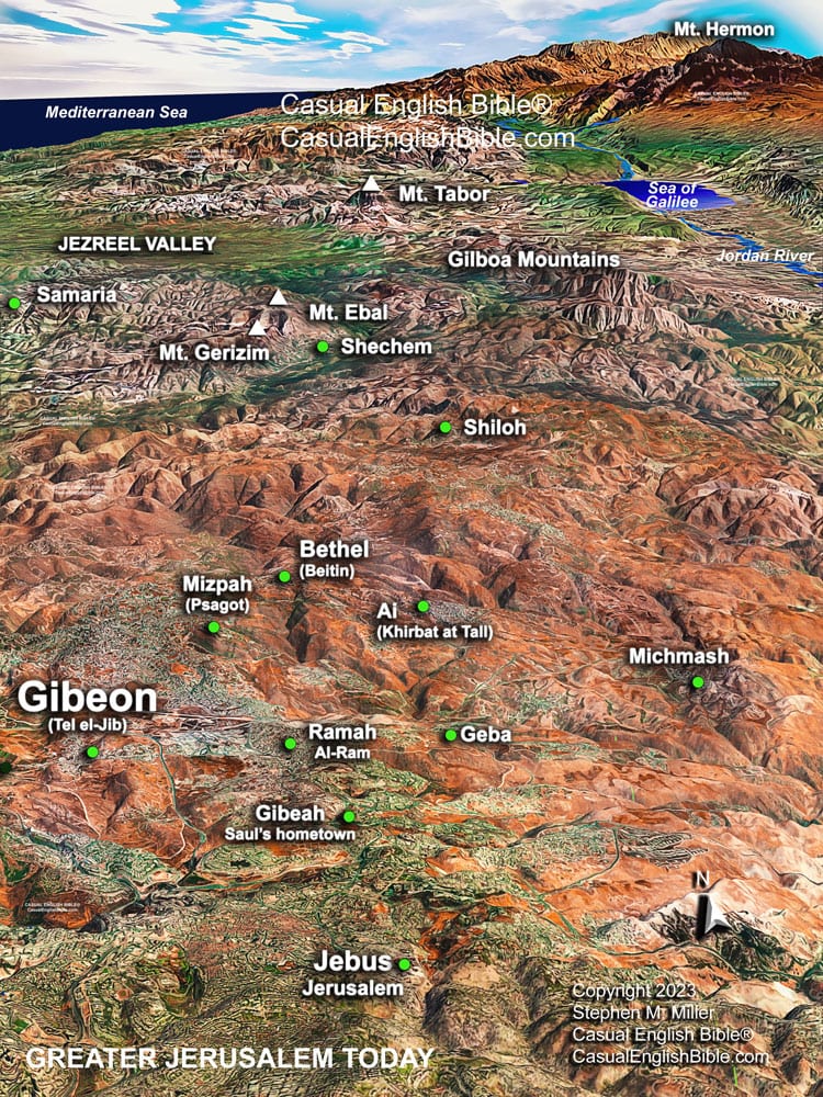
Gibeon
Gibeon, civil war begins
2 Samuel 2
BATTLE OF GIBEON
12Abner marched the soldiers of King Ishbosheth out of Mahanaim, across the Jordan River, and to the banks of a pool at Gibeon. 13David’s commander, Joab son of Zeruiah, marched his men to the other side of the pool. So, the two groups took up positions on opposite sides of the pool. 14Abner called out to Joab, “Hey, let’s have some of our men step forward and show us what they’re made of.” Joab agreed, “Okay, let them come.” 15Men stepped up and counted off. Generals limited the fight to a dozen men from each side—mortal combat, tribe against tribe. Twelve stood from Ishbosheth’s tribe of Benjamin and 12 from David’s tribe of Judah. 16Each man grabbed an enemy by the head and stabbed him in the side. They all fell together. That spot in Gibeon became known as Flint Field, for the blades that fell on the ground. 17The battle that followed was intense. David’s men won, defeating Abner’s army.RUNNING RETREAT
18David’s sister, Zeruiah, had three sons: Joab, Abishai, and Asahel. Asahel ran like a wild gazelle. 19He targeted Abner, who was retreating from the lost battle. Asahel refused to fight anyone else. He kept eyes on his bullseye, the enemy commander running away. 20Abner looked back and yelled, “Is that you, Asahel?” He said, “You bet it’s me.” 21Abner said, “Go after one of these other men and take what you want” Asahel kept gaining on him. 22Abner said, “Pick someone else. I don’t want to kill you. If I do, how could I ever face your brother Joab?” 23Asahel kept running. He ran right into the butt end of Abner’s spear. It bore through his stomach and broke through his back. Asahel, David’s nephew, dropped dead. When fellow warriors came to his body, they stood for a time in silence.King Saul’s retreat from Philistines
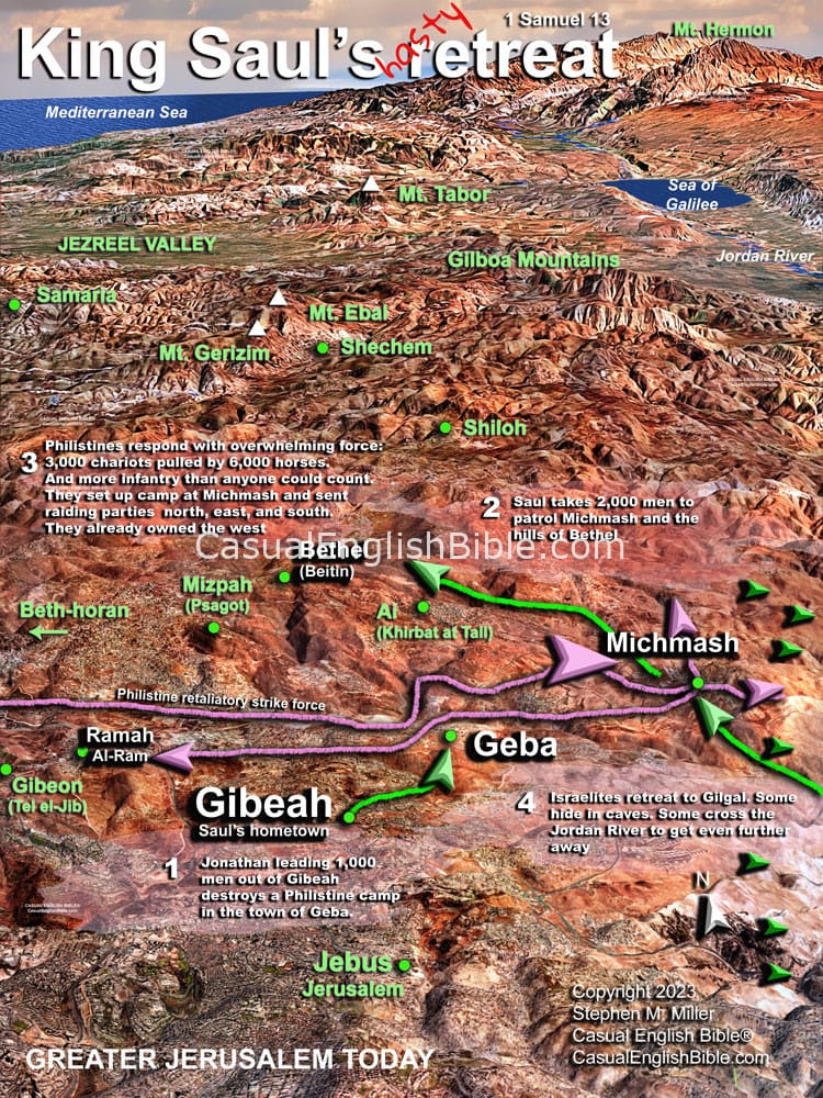
King Saul's retreat from Philistines
King Saul's retreat from Philistines
It starts when his son destroys a Philistine camp
King Saul's hasty retreat from the Philistine army began when Prince Jonathan, with a battalion of 1,000 men, attacks and destroys a Philistine camp in a small town near what is now Jerusalem. His father , King Saul, backs him up by leading 2,000 men into the area to patrol the towns and communities. Philistines retaliate with overwhelming force: 3,000 chariots pulled by 6,000 horses. And there are more infantry than anyone can count. "When Israel saw they were in trouble, most of the army retreated to anything they could crawl into or behind: caves, rocks, tombs, dry wells called cisterns, and dirt holes in the ground. They got invisible fast. Some jumped the Jordan. They crossed the Jordan River into territory of Gad’s tribe and the land of Gilead. But Saul stayed at Gilgal, with a lot of terrified Israelite citizens" (1 Samuel 13:6-7). Saul waited to attack for seven days, to give time for Samuel to get there. Samuel told him to do that. But Saul’s fighters were quickly slipping out of camp and running away. Meanwhile, Philistines set up camp in the hills around Michmash, in the area where the Israelite had been before they ran away. One more thing: "On the day of the battle, Saul and his son Jonathan each had a sword and spear. No one else did. There weren’t any weapons in town. A company of Philistines advanced to set up camp at the valley pass of Michmash." Israel didn’t have any ironsmiths who could make iron weapons or tools. Philistines outlawed it. They said, “Hebrews aren’t allowed to make swords or spears for themselves.” So, Israelites couldn’t sharpen or repair their iron plow tips, picks, axes, and sickles. They had to go to Philistine ironsmiths for that. A bronze sword doesn't hold up well against an iron one.3D Bible map of the Battle of Jabesh Gilead
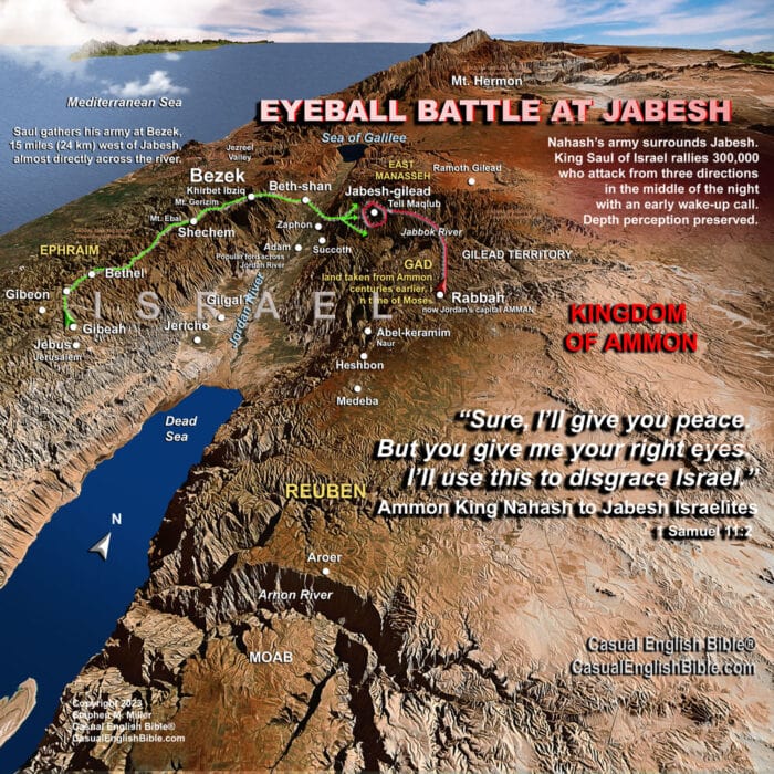
3D Bible map of the Battle of Jabesh Gilead
3D Bible map of the Battle of Jabesh in Gilead
Battle for Israel's right eyeballs and depth perception
Ammonite King Nahash takes his army and surrounds the Israelite town of Jabesh in Gilead. Centuries earlier, Moses and the invading Hebrews won the land from Ammon in a war the Ammonites started. Now King Nahash was coming to take it back...and to humiliate Israel in the process. When city leaders ask for peace terms, the king says, “Sure, I’ll give you peace. But you give me your right eyes. I’ll use this to disgrace Israel” (1 Samuel 11:2). King Saul of Israel gets the news at the end of a day of herding and farming. "God’s Spirit filled Saul and anger set him on fire. He slaughtered a team of two oxen, cut them to pieces, and dropped them in the mail—special delivery. He gave them to couriers to spread them throughout Israel. The meat came with a message: 'What happened to this ox will happen to you if you don’t come now and follow Saul and Samuel.' That terrified people. They came in a big way." He rallies an army of 300,000 Israelites.. "Saul told the messengers to say this to the people of Jabesh in Gilead, 'We’ll rescue you by the time the sun gets hot tomorrow.' People in Jabesh were elated to hear that. Jabesh Jews weren’t entirely honest with the Ammonites. They said, “We’ll surrender tomorrow, and you can do whatever you want to us.” When tomorrow came, so did King Saul. He divided his massive army into three battalions. And he surprised the enemy with a wake-up call during the early morning watch, sometime between 2-6 a.m. He slaughtered Ammonites all morning and into the heat of the day. Enemy survivors ran for their lives, scattered so wildly that each man ran on his own. Not even two ran together.". Saul preserves Israel's honor and depth perception. You can read the story in 1 Samuel 11. And you can check it out in other Bible translations at Bible Gateway.Battle of Jabesh
Map Ramah to Shiloh
Map Ramah to Shiloh
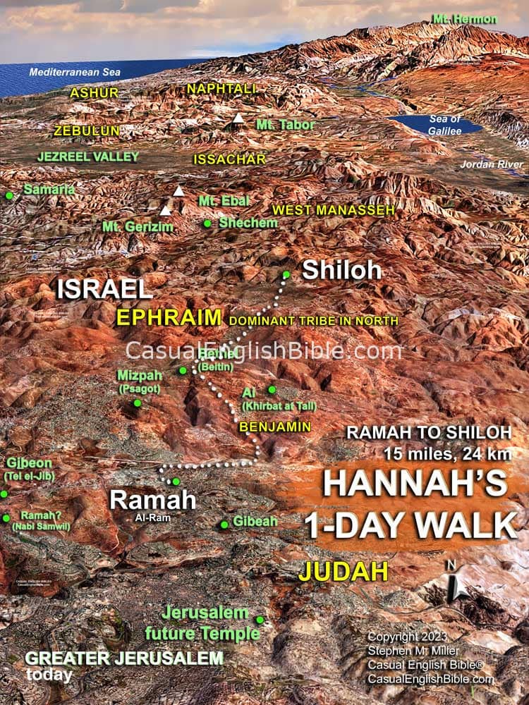
Bible map Ramah to Shiloh.
Ramah was a short version of the city’s full name, Ramathaim—a bit like LA is short for Los Angeles and KC is short for Kansas City. Ramah is usually linked to ruins called Al-Ram. It’s about 5 miles (8 km) north of Jerusalem and about 15 miles (24 km) south of Shiloh. That’s almost a day’s walk to Shiloh. Some scholars link Rama to another ruin about five miles southwest, Nabi Samwil. At the time, Jerusalem was still a generation away from when King David would capture it and turn it into his capital, the City of David.
Road from Ramah to Shiloh
Map Persian province of Judah
Map Persian province of Judah
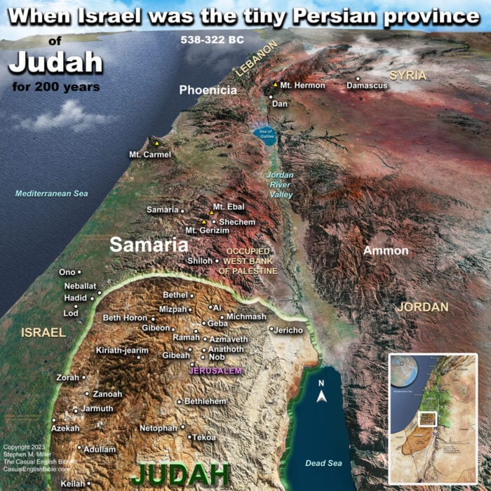
Map of the Persian province of Judah
After the Jewish nation of Judah fell to Babylonian invaders in 586, many survivors lived in exile. Some returned 50 years later, when Persians freed them.
It was only a partial freedom. The Jews lived for the next 200 years as a tiny province of Persia: Yehud, which is translated "Judah" or "Judea."
It was roughly a 40-mile-wide square plug of ground (60 km), in territory that became known as Palestine. The Jewish province included Jerusalem and beyond, into what are now central parts of Israel and Occupied Palestinian Territories.
Jerusalem is where Jews sacrificed animals to God. So when the Jews returned, they built a new temple and later restored some of the walls around the city, but not to the larger size it was before the defeat.
Map of Judah as a Persian province

