Mt Gerizim, Mt. Ebal
Mount Gerizim and Mount Ebal map

Mount Gerizim and Mount Ebal map
Mount Gerizim and Mount Ebal map. When the Israelites entered the land of Canaan, Moses explained that Mount Ebal was to be used for curses and Gerizim for blessings.
Mt Gerizim, Mt. Ebal
Boundary of Promised Land

Boundary of Promised Land
Boundary of Promised Land
After King David died, his son Solomon didn't waste time. He took charge of the kingdom like a boss. But he didn't stop there—he wanted to make the nation even stronger and richer? Solomon wasn't about to let his enemies walk all over him. He gathered his troops and went on the offense against hostile neighbors: Moabites, Ammonites, Edomites, and even the Philistines. His enemies learned quickly learned not to mess with him. Solomon also had a knack for business. He knew the importance of expanding his kingdom's wealth. So, he started making big trade deals with countries like Egypt and Phoenicia. He brought in all sorts of extravagant products—gold, silver, horses—you name it. His kingdom turned into this buzzing hub where people from all over would swing by to trade and network.
Solomon's harem
And there were the women. King Solomon, renowned for his wisdom, unfortunately succumbed to the allure of foreign women. Despite divine warnings against marrying multiple wives, he married an astounding 700, along with 300 concubines. These unions were politically motivated, aimed at forging alliances and establishing bonds with neighboring nations. However, these marriages ultimately led Solomon to idolatry, as his wives introduced foreign gods and rituals into his kingdom. This deviation from worshiping God alone, as Jewish law required, displeased the Lord, who eventually punished Solomon for his sins.Solomon beautifies Jerusalem
Jerusalem became the pride and joy of Solomon's reign. He had big plans for the capital city. He went all out and built this beautiful temple for the Almighty himself. Picture this: gold decorations, exquisite furnishings, and amazing artwork everywhere you looked. People were absolutely dazzled by it and came from far and wide just to see it. Jerusalem became the talk of the region.WHERE TO FIND MORE BIBLE MAPS
The Casual English Bible® has more than 900 Bible maps, many in 3D style. You can search for maps by place name, such as "Sea of Galilee."Dedicated Bible map search engine
But you can also search for maps by Bible book, such as searching for all the maps in the book of Joshua. In addition, you can search by country, region, or era on a timeline, such as when Israel had kings or when Jesus was on earth. Here's a link to the dedicated Map Search Engine.For more Bible features
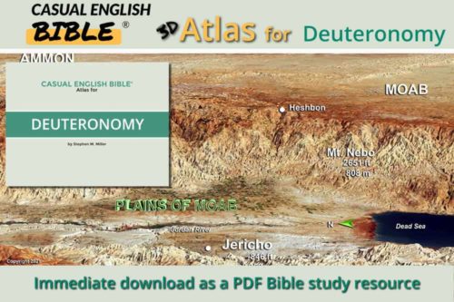
Map Plains of Moab

Map Plains of Moab
Plains of Moab
Map View from Mount Nebo

Map View from Mount Nebo
View from Mount Nebo
Mount Nebo has the highest summit on the plateau, at 2,300 feet elevation, or 710 meters. That’s an especially good vantage point to view what is now Israel and Palestinian territories since the Dead Sea is about 1,400 feet below sea level, or 430 meters. That’s more than a kilometer above the Jordan River Valley, about three-fourths of a mile.Why God didn't let Moses into Promised Land
Scholars debate why God reacted wouldn't let Moses into the Promised Land of Canaan. Two popular guesses:- God told Moses to merely speak to the rock, but Moses angrily hit it with a stick—twice. Also, Moses seemed to take some credit for the miracle when he said “Do we have to bring water from this rock” (Numbers 20:9). As in God and Moses, the tag team? Some scholars say God’s complaint about Moses and Aaron in Numbers 20: 12 and 24 seem like an overreaction to what the men did.
- So, another guess is that the writer didn’t want to report what really happened. Instead, he wanted to protect the reputation of the men.
Notes
- Mountains east of the Jordan River. It includes Mount Nebo and extends south.
- Across the Jordan River from Jericho.
- It’s unclear where Mount Hor was. There’s a long tradition that connects it to Jebel Nabi Harun (Mountain of Prophet Aaron), roughly a day’s walk south of Edom’s capital city of Petra. Some scholars say that mountain was well inside the country of Edom, which is where the Israelites were forbidden to go. Another contender is Jebel Madurah. It was about a two-day walk northwest of Petra. The mountain is southwest of the Dead Sea, along what would have been the border of the Promised Land and Edom.
- Literally “the waters of Meribah-kadesh.” Meribah means to fight, argue, complain, rebel. Kadesh is a location. Scholars most often identify Kadesh, also called Kadesh Barnea, as the spring-fed oasis at Tel el-Qudeirat, on Egypt’s side of the border with Israel. Another contender is Ain Qadeis, also on Egypt’s side of the border. Bible writers put the location in different deserts: Zin Desert (Numbers 20:1) and Paran Desert (Numbers 13:26). Some theorize there were two Kadesh oases. West Kadesh and East Kadesh. Not many scholars seem to buy into that. The story of Moses disobeying God, as reported in Exodus, says Moses named the site “Pushy Complainers,” or literally in the Hebrew name, “Massah Meribah.” Massah means to test or to get pushy.
View from Mount Nebo
Acacia Grove camp

Acacia Grove camp
Tent worship center

Tent worship center
Tent worship center
aka The Tabernacle
The Casual English Bible says the Tent Worship Center, also known as the Tabernacle, was a portable temple that the Israelites carried with them during their wanderings in the wilderness.
The Tabernacle was the center focus of their worship, and it played a crucial role in their religious and cultural identity. This is where they went to pray and to offer sacrifices to God.
Temple in a tent
The Bible describes the Tabernacle as a large tent, set up with its entrance facing the east.
Israelites divided the tent into sections. There was the Holy Place, where only the priests could go. They performed various rituals there, such as burning incense and lighting candles. There was also the Most Holy Place or the Holy of Holies. This was the most sacred room, reserved for the High Priest.
Parked inside: Ten Commandments
Israelites kept the Ark of the Covenant, which contained the Ten Commandments, in the Holy of Holies. The Bible describes the Ark as a symbol of God's covenant with Israel, and it was treated with great reverence and respect.
The Tabernacle was the site of all the main religious ceremonies, including sacrifices, offerings, and festivals. The Bible explains that the rituals were one way of helping maintain a connection with God and honoring His commands.
Temple à la cart
The Casual English Bible explains that Israelites built the Tabernacle to be portable. This allowed the Israelites to carry it with on carts as they journeyed through the deserts and badlands south of what is now Israel.
They made the worship center with of durable materials, including hard acacia wood and animal hides.
Replacing the tent with a temple
As the Israelites settled in the Promised Land, the Tabernacle was eventually replaced by the Temple in Jerusalem. However, the Tabernacle remains an important symbol of God's presence and the Israelites' journey through the wilderness.
Migrating quail

Migrating quail
Map Exodus – Grumbling at “Pushy Complainers” Spring

Map Exodus - Grumbling at "Pushy Complainers" Spring
Map route of Exodus. Grumbling at "Pushy Complainers" Spring
Grumbling at "Pushy Complainers" Spring
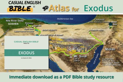
Israelite route to the Promised Land